 Campsite Atlas
Barker Recreation Area
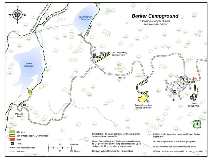
Barker Recreation Area is located high on the Colorado Plateau at an elevation of 9,300 feet. Visitors enjoy canoeing, fishing and exploring local trails. Upper Barker Reservoir provides canoeing, kayaking and fishing for rainbow and brook trout. Numerous hiking, biking and horse trails can be accessed from both the Upper and Lower Barker Reservoir trailheads. Trails, including the non-motorized Great Western Trail, lead to nine backcountry fishing lakes and beautiful mountain views. The area also has excellent stream fishing and spectacular fall colors. This recreation area contains 13 single-family sites, three group campsites and a day-use area.
Campsites
| Standard, no hookups | 13 |
| Host/management | 2 |
| Group sites | 2 |
| group standard area nonelectric | 1 |
| Total | 18 |
Amenities & rules
Compiled from site-level records; individual sites vary. Confirm on Recreation.gov or with the managing office.
Getting there
From Escalante, Utah, drive 2.5 miles west on Highway 12, then turn right at the North Creek Lakes sign and right again at the Barker Recreation Area sign, onto Forest Road 149. Drive approximately 16 miles on FR 149. The last 3.4 miles of FR 149 are steep and single-lane with switchbacks and turnouts.
Campgrounds nearby
25.5 miles away
Data source: Recreation.gov RIDB, retrieved August 30, 2026. The Campsite Atlas is an independent publication and is not affiliated with or endorsed by the Recreation.gov or any federal agency. Always confirm critical details on the official Recreation.gov page before you travel.